
Ohio Distribution System Hosting Capacity Map
Welcome to FirstEnergy’s Ohio Distribution System Hosting Capacity Map. This interactive map provides estimated hosting capacity for distribution and sub-transmission facilities to help developers identify locations that may be suitable for new generation, load or battery installations.
Hosting capacity analysis assesses how much additional generation, load or battery capacity can be accommodated by Ohio Edison, The Illuminating Company and Toledo Edison’s (“company” or “companies”) existing system without requiring infrastructure upgrades or equipment changes.
Developers must submit a completed application for company review and approval prior to construction and interconnection.
Capacity Map Overview
- The map offers potential locations within the companies’ systems where generation, load or battery projects may be feasible. This map should not be used for other purposes.
- Interconnection, net metering, battery or new load applications in the companies’ queues may take up capacity and not be reflected on this map.
- Single-phase or double-phase sections of the companies’ circuits may have lower capacity than indicated on this map. Networked distribution feeders are not mapped.
- Applications will still be accepted on circuits mapped with no available capacity remaining. The project’s capacity requirements will determine if the application can be approved or if a detailed load study will be needed.
- Service transformers, service conductors or other infrastructure upgrades may be required to support your project. The need for infrastructure upgrades is determined during the application process, and associated costs are the responsibility of the applicant under Ohio law. Any potential upgrades needed are not reflected on this map.
Disclaimer
The information displayed on the companies’ map is for information and guidance only. All proposed generating systems, loads or batteries must be submitted to the company with a fully completed interconnection, net metering or new load application for a comprehensive technical review through the established process. The hosting capacity data displayed on the map is captured as of the date indicated on the map and may not reflect current system conditions. The companies and their affiliates do not guarantee the accuracy of the information on this map.
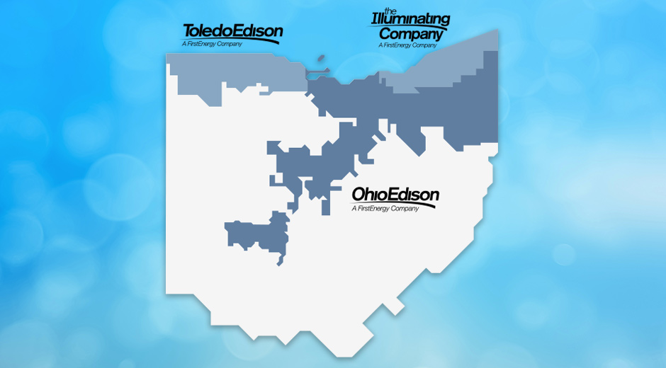
Search Hosting Capacity Map
Click the Search Capacity button below and enter the ZIP Code or address to find the electrical feeders near you.
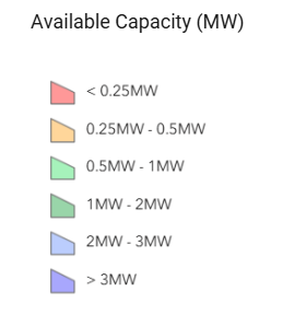
Map Legend
Hexagons on the map represent the estimated maximum hosting accommodation limit for distribution and sub-transmission locations. Select a hexagon to display the estimated maximum available capacity.
-
What is Hosting Capacity?
Hosting capacity analysis assesses how much additional generation, load or battery capacity can be accommodated by Ohio Edison, The Illuminating Company and Toledo Edison’s (“company” or “companies”) existing system without requiring infrastructure upgrades or equipment changes.
-
What is the purpose of the hosting capacity map?
The map offers potential locations within the companies’ systems where generation, load, or battery projects may be feasible.
-
How is hosting capacity calculated?
Hosting capacity is calculated via a power flow analysis software. Each feeder and substation is analyzed individually to estimate the amount of generation, load or battery that can be safely interconnected without adversely affecting the system. Presently only thermal, voltage deviation, and Ground Fault Overvoltage 3V0 constraints are considered in calculating the available hosting capacity for a location.
-
What is excluded from the analysis?
The map currently excludes networks dedicated to individual customers or those supporting critical infrastructure
-
How frequently is the map updated?
Each quarter the queued load, queued generation, queued battery and any circuits that have undergone major topological changes are refreshed. Full system analysis is conducted yearly.
-
How do I submit a request for service?
- Interconnection Application
Ohio Retail Interconnection
- New Construction, Temp to Perm and Upgrades
Construction & Renovation
- Interconnection Application
-
What do the data fields mean?
Data Definition Map Grid ID
Unique identifier for an area of the map
Feeder ID (Dist.)
Unique circuit name
Feeder Voltage (Dist. kV)
Circuit primary voltage at selected location
Available Capacity (Dist.) (MW)
The maximum hosting capacity at any node on the displayed circuit
Limiting Factor (Dist.)
The constraint that is limiting further capacity (Thermal, Voltage Deviation, Ground Fault Overvoltage 3V0)
In Queue Load (Dist.) (MW)
Sum of load queued
In Queue Generation (Dist.) (MW)
Sum of DERs in queue
Total In Service Generation (Dist.) (MW)
Sum of in-service DER
Line Name (Sub-Trans.)
Unique Sub-Trans. line name
Available Capacity (Sub-Trans.) (MW)
The maximum hosting capacity at any node on the displayed Sub-Trans. line
Feeder Last Update
Date and time of last update
Substation Name
Unique Substation name
Nominal Voltage (Dist.) (kV)
Nominal primary voltage at the Substation
Available Capacity (Dist.) (MW)
The maximum hosting capacity for any node on the displayed Substation